Wednesday, March 31, 2010
Read Mississippi Engineering Group's Report (PDF)
After four years of waiting, Mississippi Engineering Group Inc. finally delivered to the Rankin-Hinds Pearl River Flood and Drainage Control District Levee Board its 28-page draft of its economic-impact report on a Lower Lake Plan for flood control along the Pearl River.
The draft, financed through the non-profit Lefleur Lakes Development Foundation, arrived after years of battle between Levee Board members over whether to accept a levee expansion endorsed by the U.S. Army Corps of Engineers or a lake plan promoted by developers promising to contain the Pearl River.
Members of the board created the foundation in 2005 as a means to draw down federal grants and money from the Mississippi Development Authority, and explore economic-development opportunities in connection with flood control. Members of the Levee Board comprise the foundation, but the board remains focused on a partnership for flood control with the Corps.
The report clearly adopts ideas of internationally known architect Andres Duany, who rejected a larger lakes plan proposed by Jackson oilman John McGowan--which the Corps estimates to cost more than $1 billion due to environmental issues. Duany told the Jackson Free Press last year that he disagreed with any plan that would devastate more than 7,000 acres of hardwood wetland along the Pearl River, and criticized developers for writing off a treasured resource.
"How many cities can boast of a wetland so close to the city's center?" Duany said. "This is not the kind of thing you destroy. This is an enhancement for the city."
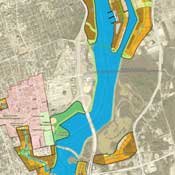
The smaller Lower Lake Plan would create one 6.5 mile-long lake, which is cheaper and less environmentally invasive than Two Lakes, but would have close to the same amount of flood control, supporters say. The lake, nevertheless, faces environmental opposition. Its current design will inundate a large portion of LeFleur's Bluff Park, including the Mayes Lake campgrounds.
Mississippi Wildlife Federation Director Cathy Shropshire, like Duany, feared the inundation by the Lower Lake of a scenic area distinctive for its size in a metropolis.
"To have a getaway of that size right in the metropolitan area makes it truly unique. You just don't get 300 acres of a nice park-like area in the middle of a big city like this unless you live in an area like Vancouver or New York City. Most places don't have that kind of value. They've developed everything around them," she said.
Environmentalists suggest that engineers lower the lake level to avoid swamping the campgrounds further north, but Waggoner Engineering Inc. project engineer Barry Royals warned that the lake was already averaging less than 10 feet in depth, and that lowering the lake's depth further might expose the southernmost portion of the lake, near the Interstate 20 underwater dam, to seasonal drying.
"That area would get filled with weeds and debris and wouldn't be worth anything as far as development," Royals told the Jackson Free Press. "You couldn't build on it, and it sure wouldn't be pretty to look at."
The report anticipates the construction of the Lower Lake Plan to cost $605 million, including $50 million for land acquisition, financed by a district expansion and subsequent property tax increases in the area. Taxpayers would have to find $472 million after the federal government's $133 million co-payment for flood control.
The economic-impact report includes a chart of debt payments, based on an annual payment of $13.8 million per $200 million bond issue, and a 30-year term at 5.5 percent interest. The chart reflects a $12 million loss in the first year as taxpayers pay the up-front costs of the project, with that figure improving little over the next two years. The chart suggests a $3 million loss on the project in the fourth and fifth years, which then becomes a net gain in the sixth year of less than $1 million thanks to lease revenue generated by new lakefront property. The chart anticipates the gain to grow to an average of $12 million a year for the last five years of the life of the bond issue.
The report suggests an influx of businesses to the new lakefront property would help support the 30-year tax burden. Engineers plan development to frame the lake on both the Rankin and Hinds county sides and design the lake to contain two islands accessible by existing Jackson and Rankin county roads. This plan includes a proposal for the development of a waterfront pedestrian promenade on Town Creek, similar to that of San Antonio's Riverwalk, as promoted by Jackson Mayor Harvey Johnson Jr. and others.
Planners expect the development along the shoreline and islands to be mixed-use neighborhoods consisting of single-family and multi-family housing, retail and commercial properties, as well as parks and civic spaces, a marina facing downtown Jackson, and a series of parks along the levees. Engineers envision some neighborhoods having a high-density, urban feel, while others will have a spacious, residential feel. Zoning categories around the lake include: Rural, Sub-Urban, General Urban, Urban Center and Urban Core, with neighborhoods limited in size by a five-minute walking limit from the edge to shops, workplaces and civic buildings in the center.
The report paints a pretty picture, but opponents of the Lower Lake Plan contend that engineers are overstating the amount of development by de-emphasizing the scenic damage of the levees. Any business sitting at the edge of the lake's water would have to be on the river side of the levee, and subject to the river's seasonal lack of mercy. Any new business on the safe side of the levee must contend with the unseemly view of a grass-covered, 20-foot levee rather than a pristine lake, they say.
Placing businesses directly on the levees are unlikely. Tom Pullen, a Byram resident and a former Corps employee, points out that the Corps does not generally approve construction directly on levees. In fact, the Corps only allows trees to grow on a levee if the levees are of sufficient size and strength to accommodate the tree roots. "They don't usually want anything to potentially tear those levees apart or damage them," Pullen said.
The Corps offices in Vicksburg sit atop a reinforced levee, but reinforcing the levees around the Pearl for housing foundation adds considerably to the $206 million price of the levee extension.
Royals said the project plan predicts considerable business to be housed upon the lake's two islands, which contain high enough floodwalls to handle a 200-year flood event similar to the 1979 flood--which inundated considerable portions of Jackson.
"The shoreline around the lake is developable, in my opinion. You can build in behind existing levees now on the east side in the Flowood area. A lot of the area in downtown Jackson sits on natural bluffs. The old city barn, where the old dog pound was, presents a great spot," Royals said, discounting worries of a levee ruining a picturesque view of a lake.
"There've been 20-foot levees all around this area for umpteen years, but I don't hear anyone complaining about the height of the levees now. I don't see why businesses behind the levees should not be able to see the lake," Royals said.
The Corps will begin its final report following the Levee Board's December approval of the levee expansion plan this year. The Corps predicted last September that the report would require 18 months to complete and cost $1 million. The board will work in the next few months to tweak the levee-expansion plan they approved to allow space and design changes to accommodate a lake. Members of the board suspect that any construction of the Lower Lake may have to wait until the Corps finishes the levee expansion. Board members are unsure of the Lower Lake timeline, because the Corps has not officially endorsed the construction of the Lower Lake.
Of course, the question of any lake could be moot if the Corps retains its stance against impoundment. The Levee Board adopted the Corps-endorsed levees-only plan over the $1.4 billion Two Lakes Plan last year, but with the condition that the Corps consider allowing a smaller 1,500-acre lake between the levees at a later, undefined, date, and that the Corps agree to design modifications that would better accommodate a levee-locked lake.
Corps Chief of Project Management Doug Kamien told the Levee Board last September that the Corps approved the levee plan almost exclusively due to environmental impacts of any plan to impound the Pearl River.
Corps spokesman Frank Worley says the Corps has not changed that stance since September, which may have prompted the Levee Board to write a March 2 letter to the Corps reminding the federal agency of the board's desire for a modest lake between the levees.
A majority of the board, including Chairman Billy Orr, wants the Lower Lake Plan intact. Two board members, Leland Speed and Socrates Garrett, lobby for the McGowan plan. Speed has said he doubts the smaller Lower Lake Plan can happen due to the more limited development opportunities to offset its $605 million cost.
For the JFP's full coverage of Two Lakes and Levees, visit the The Pearl River Archive.
Comments
Use the comment form below to begin a discussion about this content.
Sign in to comment
Or login with:
OpenID